Coastal and Oceanic Landform ( 37. Oceanic Trench )


                                                                                                                                         Back to Coastal and Oceanic Landform


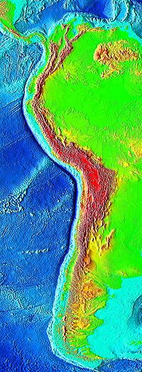
The Peru-Chile Trench
Major Pacific trenches 
1.Kermadec
2.Tonga
3.Bougainville
4.Mariana
5.Izu-Ogasawara
6.Japan
7.Kuril-Kamchatka
8.Aleutian
9.Middle America
10.Peru -chile

Fracture Zones
11.Mendocino
12.Murray
13.Molokai
14.Clarion
15.Clipperton
16.Challenger
17.Eltanin
18.Udintsev
19.East Pacific Rise (S-shaped)
20.Nazca Ridge


  • The oceanic trenches are hemispheric-long scale but narrow topographic depressions of the sea floor. 
  • They are also the deepest parts of the ocean floor.
  • Oceanic trenches are a distinctive morphological feature of convergent plate boundaries.
  • Plates move together  few mm to over ten cm per year.
  •  A trench marks the position at the flexed.
  • subducting slab begins to descend beneath another lithospheric slab.
  • Trenches are generally parallel to avolcanic island arc.
  • Typically extend 3 -4 km.

Location of the Mariana Trench

  • The greatest ocean depth  is in the Challenger Deep of the Mariana Trench.
  • Depth of 10,911 m below sea level.
  • Oceanic lithosphere moves into trenches at a global rate of about 3\,\text{km}^2/\text{yr}.
  • Trenches are sometimes buried and lack bathy metric expression.
  • Trenches along with volcanic arcs and zones of earthquakes.

  • There are several factors that control the depth of trenches;

-supply of sediment
-age of the lithosphere at the time of subduction. 


  • Relative depth may be controlled by ;
               the age of the lithosphere at the trench
               the convergence rate
              the dip of the subducted slab at intermediate depths

  • Narrow slabs can sink and roll back more rapidly than broad plates.
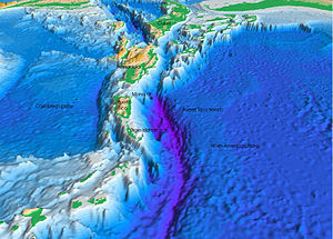
The Puerto Rico Trench

Coastal and Oceanic Landform ( 36. Oceanic Plateau)


                                                                                                                                         Back to Coastal and Oceanic Landform
Mascarene Plateau
Mascarene Plateau

  • An oceanic plateau/submarine plateau is a large.
  • Relatively flat.
  • Rises well above the ambient seabed.
  • Oceanic plateaus are composed;

                                 -continental crust.
                                - step interrupting the continental slope


  • Some plateaus are under sea remnants of large igneous provinces.
  • These were formed by continental flood basalts.

                         -Deccan Traps in India
                        - Snake River Plain in the Pacific Northwes

Ontong Java Plateau,Pacific Ocean

  • Continental crust has the highest amount of silicon.
  • Oceanic crust has a smaller amount of silicon.
  •  Igneous oceanic plateaus have a ratio intermediate between continental and oceanic crust.

  • Igneous oceanic plateau is subducted underneath another one.

Naturaliste Plateau
Naturaliste Plateau

examples
  • Campbell Plateau (South Pacific)
  • Challenger Plateau 
  • Agulhas Plateau (Southwest Indian)
  • Broken Ridge Plateau (Indian)
  • Caribbean-Colombian Plateau (Caribbean)
  • Exmouth Plateau (Indian)
  • Hikurangi Plateau (Southwest Pacific)
  • Kerguelen Plateau (Indian)
  • Manihiki Plateau (Southwest Pacific)
  • Mascarene Plateau (Indian)
  • Naturaliste Plateau (Indian)
  • Ontong Java Plateau (Southwest Pacific)
  • Shatsky Rise (NorthPacific)
Zealandia Hikurangi Plateau


the red patch below the plateau is the continent of Antarctica


Coastal and Oceanic Landform (35.Oceanic Basin)

                                                                                                                                         Back to Coastal and Oceanic Landform


  • An oceanic basin covered by seawater.
  • Ocean basins are large basins  below sea level.
  • There are under sea features;

                                                 continental shelves
                                                 deep ocean trenches
                                                 undersea mountain ranges

  • There are complement to the continents, with erosion.
  • Sediments derived ending up in the ocean basins.
  • Most Ocean basins  as basaltic plains, than as sedimentary depositories.


  • Basins are both above and below sea level;

                                                     Maracaibo Basin in Venezuela
  • Oceans cover 70% of the Earth's surface.
  • Oceans lie lower than continents, the former serve as sedimentary basins.
  • Is serve as repositories for the skeletons of carbonate- and silica-secreting organisms;

                                                    coral reefs
                                                    diatoms
                                                    radiolarians
                                                    foraminifera.
Oceanic basin  actively changing size /relatively, tectonically inactive, depending on whether there is a moving plate tectonic boundary associated with it.
The elements of an active& growing
                                                   elevated mid-ocean ridge
                                                   flanking abyssal hills leading down to abyssal plains.
                                                   oceanic trench associated with a subduction zone.

examples of active Oceanic basin
The Atlantic ocean 
The Arctic ocean
The Pacific Ocean

examples of growing Oceanic basin
The Mediterranean Sea
The Pacific Ocean

example of an inactive oceanic basin
The Gulf of Mexico in Jurassic
The Aleutian Basin

Coastal and Oceanic Landform ( 34. Ocean)


                                                                                                                                         Back to Coastal and Oceanic Landform

  • An ocean is a body of saline water.
  • It composes a large part of a planet's hydrosphere.
  • World Ocean –

               1.Pacific Ocean        =  Separates Asia & Oceania from the Americas
              2.Atlantic Ocean       =  Separates  the Americas from Eurasia & Africa
              3.Indian Ocean        =   Washes upon southern Asia & separates Africa &  Australia
             4.Southern Ocean    =   Pacific, Atlantic &  Indian Oceans encircles Antarctica
            5.Arctic Ocean           =   Covers Arctic & washes northern North America & Eurasia

  • The word "sea" is used interchangeably with "ocean".
  • Ocean is the largest confirmed surface.
  • Approximately 72% is covered by saline water.
  • Hydrosphere in the Earth, the ocean contains 97% of the Earth's water.
  • Only 5% of the ocean as a whole in Earth has been explored.
  • The world ocean is part of the carbon cycle.
  • An average depth of 3,682 metres (12,080 ft).
  • It is the habitat of 230,000 known species.
  • Oceans may also exist on exoplanets and exomoons.


  • The area of the World Ocean is 361 million square kilometres.
  • The deep ocean cover about 66% of the Earth's surface.
  • The deepest point in the ocean is the Mariana Trench (10,971 m ), located in the Pacific Ocean near the Northern Mariana Islands.


  • The ocean has a significant effect on the biosphere.
  • Oceanic evaporation.
  • Ocean temperatures determine.
  • climate &  wind patterns that affect life on land.


Lifeforms native to the ocean include:
  • Fish
  • Radiata
                         jellyfish

  • Cetacea 
                      whales
                     dolphins
                     porpoises

  • Cephalopods
                    octopus
                    squid

  • Crustaceans
                      lobsters
                     clams
                     shrimp
                    krill

  • Marine worms
  • Plankton
  • Echinoderms
                             brittle stars
                             starfish
                            sea cucumbers
                            sand dollars


Coastal and Oceanic Landform (33. Mid Oceanic ridge )


                                                                                                                                         Back to Coastal and Oceanic Landform


  • A mid-ocean ridge called as an underwater mountain system.
  • It consists of various mountain ranges.
  • The uplifted seafloor results from convection currents.
  • which rise in the mantle as magma at a linear weakness in the oceanic crust.

Including a black smoker
  • Emerge as lava.
  • Creating new crust upon cooling.
  •  A mid-ocean ridge boundary between two tectonic plates.
  • consequently is termed a divergent plate boundary.
  • It connected & form a single global mid-oceanic ridge system.
  • That is part of every ocean.
  • There are  the longest mountain range in the world.
  •  The continuous mountain range is 65,000 km long.
  • The total length of the oceanic ridge system is 80,000 km.


  • Mid-ocean ridges are active, with new magma.
  • The crystallized magma forms new crust of basalt gabbro.
  • Oceanic crust in the ocean basins is less than 200 million years old.
  • Slow spreading ridge Mid-Atlantic Ridge have large, wide rift valleys. 10–20 km.
  • fast spreading ridges like the East Pacific Rise are narrow, sharp.
A close-up showing a mid-ocean ridge topography with magma rising from a chamber below, forming new ocean plate which spreads away from ridge
Mid-ocean ridge,magma rising from a chamber below, forming new ocean plate which spreads away from ridge


  •  There are two processes;
                                                             ridge-push 
                                                             slab pull

  • Ridge-push= growing bulk of the ridge.
                                        pushes the rest of the tectonic plate away from the ridge
                                        towards a subduction zone.
  • Slab-pull =    this is simply the weight of the tectonic plate.
                                      subducted (pulled) below the overlying plate.
                                      dragging the rest of the plate along behind it.


  • The other process contribute to the formation of new oceanic crust at mid-ocean ridges is the "mantle conveyor".

  • Mid-ocean ridge creates new material spreading rate measured in mm/yr.
  • The common subdivisions of spreading rate;

                                                            >100 mm/yr
                                                           100–55 mm/yr
                                                           55–20 mm/yr


Coastal and Oceanic Landform (32.Marine Terrace)

                                                                                                                                        Back to  Coastal and Oceanic Landform


Typical sequence of erosional marine terrace;

1.Low tide cliff
2.Modern shore platform
3.Inner edge
4.Modern sea cliff
5.Old shore platform
6.Paleo shorelineangle
7.Paleo sea cliff
8.Terrace cover deposits
9.Alluvial fan
10.Decaved and covered sea cliff & shore platform
11.Paleo Sea level  I
12.Paleo Sea level  II


  • A rock terrace formed a sea cliff, with a   wave- cut platform before it, is raised above sea level. 


examples ;
                   California
                   Oregon
                   Chile
                   Gibralta
                   New Zealand
                   Other islands of the Pacific


lowest marine terrace at Tongue Point, New Zealand


  • marine terrace called as coastal terrace.

  • Raised beach or perched coastline is  relatively flat.

  • Horizontal or gently inclined surface of marine origin.

  • It is bounded by;

                                          -a steeper ascending slope on the landward side.
                                          -a steeper descending slope on the seaward side


marine terrace ,Santa Maria Island, south-central Chile.


  • The platform gradient between 1°- 5°.
  • The width is reaching up to 1000 m.
  • It seems to differ between northern and southern hemisphere.
  •  Sub-horizontal platforms usually terminate in a low tide cliff.
  •  Marine terraces  extend for several tens of kilometers parallel to the coast.
  • Older terraces are covered by marine / alluvial materials.
  • Marine terraces can be covered by a wide variety of soils.
  • In protected areas allochtonous sandy parent materials from tsunami deposits may be found.
  • Common soil types found on marine terraces include planosols and solonetz.
marine terraced ,north of Santa Cruz, California

marine terraces at Tongue Point, New Zealand